North America is gearing up for a spectacular celestial event as a total solar eclipse is set to grace the skies on April 8, 2024. The eclipse, which occurs when the moon passes between the sun and Earth, will cast a historic shadow across parts of the United States, Mexico, and Canada. However, even for those in the path of totality, weather conditions could play a crucial role in visibility.
See Where To Avoid Clouds For April 2024 Total Solar Eclipse | Details
North America is gearing up for a historic total solar eclipse on April 8, 2024, spanning parts of the United States, Mexico, and Canada. However, the visibility of this celestial event may be affected by weather conditions, with clear skies crucial for optimal viewing.
According to NASA, a total solar eclipse occurs when the moon completely blocks the face of the sun for a short time. The "path of totality" refers to the specific locations on Earth that fall directly under the centre of the moon's shadow.
The upcoming eclipse will traverse Mexico, the United States, and Canada. NASA reports that another total solar eclipse will not grace North America for another two decades, making this event a must-see for skywatchers.
Fred Espenak, a former astrophysicist from NASA Goddard Space Flight Center, emphasises the importance of clear skies for optimal viewing. "You want to avoid any type of cloud, if you can," Espenak told ABC News. "All you need is for one of those clouds to be in front of the sun and you've missed the total eclipse."
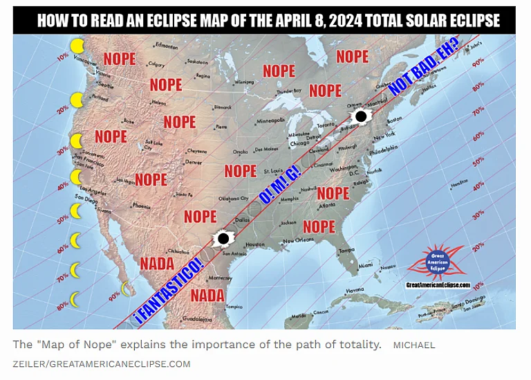
In the United States, the path of totality will begin in Texas and journey through several states, including Oklahoma, Arkansas, Missouri, Illinois, Kentucky, Indiana, Ohio, Pennsylvania, New York, Vermont, New Hampshire, and Maine. Parts of Tennessee and Michigan will also experience the total solar eclipse.
Espenak suggests that viewing the eclipse in the southern parts of the US may offer the best chances for clear skies. However, cloud cover forecasts for April 8 are still unavailable.
The National Centers for Environmental Information (NCEI) created an interactive map based on U.S. Climate Normals to illustrate average weather conditions along the path of totality. According to the map, Texas, Oklahoma, and southeast Missouri are among the top three areas with the highest likelihood of clear skies.
While specific cloud cover forecasts are unavailable, past weather data can provide some insight. On April 8, locations along the path of totality may experience varying degrees of cloud coverage.
According to data from the National Oceanic and Atmospheric Administration (NOAA), the expected cloud coverage on April 8 is as follows:
Dallas, Texas: Approximately 54% of the sky will likely be mostly cloudy or overcast, while around 46% is expected to be clear to partly cloudy.
Little Rock, Arkansas: Anticipated cloud cover indicates that about 51% of the sky will be mostly cloudy or overcast, with approximately 49% clear to partly cloudy skies.
Indianapolis, Indiana: It's projected that around 66% of the sky will be mostly cloudy or overcast, leaving about 34% with clear to partly cloudy conditions.
Buffalo, New York: Cloud coverage is estimated at roughly 67% for mostly cloudy or overcast skies, with approximately 33% expected to be clear to partly cloudy.
Despite the uncertainty of weather conditions, Espenak encourages everyone to witness this rare event. "Seeing a total eclipse is something that should be on everybody's bucket list," he said. "It's an incredible event that will be something that people will remember for their entire lives."

