In a satellite image, the National Remote Sensing Centre (NSRC) showed the impact of the Wayanad landslides in which over 200 people have lost their lives, with the toll expected to go higher as the work to retrieve bodies remains on and the operation to pull out survivors having been concluded.
NRSC is one of the centres of the Indian Space Research Organisation (ISRO) and manages data from aerial and satellite sources.
The NSRC said a major debris flow was triggered by heavy rainfall in and around the Chooralmala town of Wayanad District in Kerala state of India.
A "3D rendition of the crown of the landslide" illustrated that a large section of the hill slope was affected, the NSRC said.

The areal extent of the landslide is 86,000 sq.m, it said, adding that the crown is located at an approximate elevation of 1,550 m above the Mean Sea Level (MSL).
Interestingly, both NSRC and ISRO presented evidence of an old landslide at the same location. ISRO has a "Landslide Atlas of India" which documents the 80,000 landslides that have taken place over 20 years and lists landslide from Puthumala, Wayanad district, and large parts of Kerala marked red as being prone to landslides.


The latest ISRO report, cited in an NDTV report, suggested that there is evidence of an old landslide at the same location. A 2023 'Landslide Atlas of India' prepared by ISRO had placed Wayanad region as a vulnerable to landslides.
In another set of satellite images, NRSC reports says "a major debris flow was triggered by heavy rainfall in and around the Chooralmala town of Wayanad District in Kerala state of India".
"Very high resolution RISAT SAR images of 31 July, 2024 show the entire extent of the debris flow from crown to end of run out zone. The approximate length of the flow is 8 km. The crown zone is a reactivation of an older landslide," NSRC said.
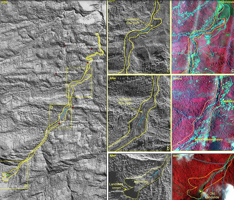
"The size of the main scarp of the landslide in 86,000 square meters. The debris flow has widened the course of the Iruvaniphuza River causing breach of its banks. Houses and other infrastructures located along the banks have been damaged by the debris flow," NSRC said.