Southern district Karnataka witnesses rare October rain in Bengaluru as the city faces traffic snarls and several schools remained shut on Monday. Meanwhile a cyclonic storm has been forming over Bay of Bengal, according to India Meteorological Department which is expected to hit Puri in Odisha and Sagar Islands in West Bengal.
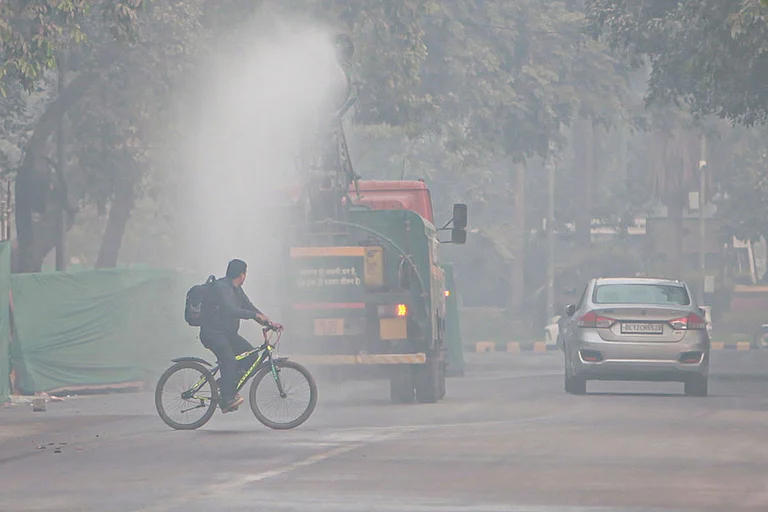
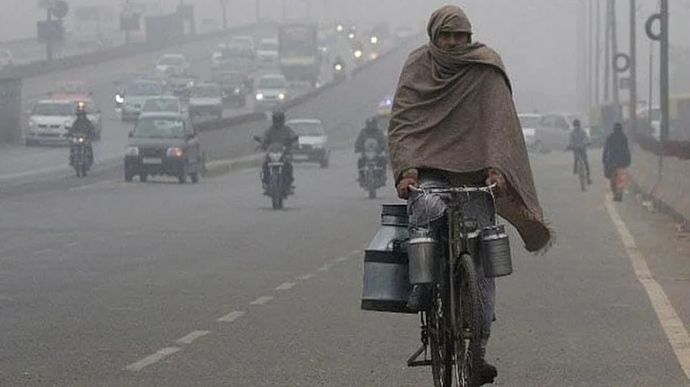
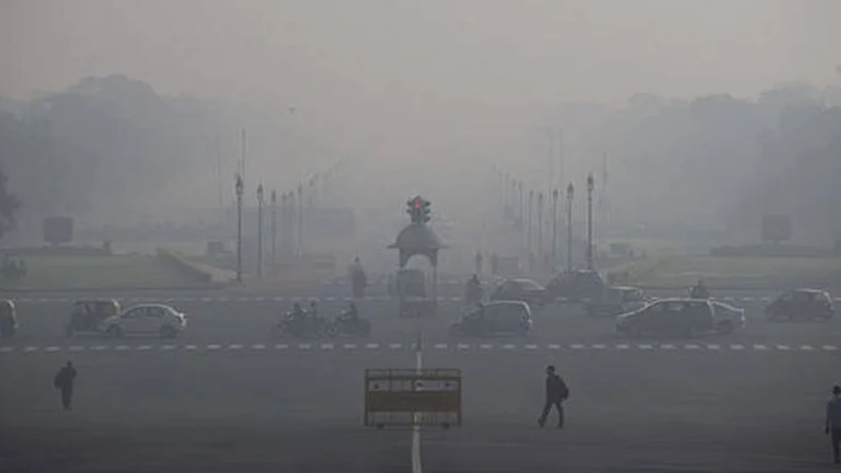
Delhi pollution becomes worse as out of 36 monitoring stations, 26 of them were marked in the red zone as air quality index reads it 'very poor'.
Karnataka: Rare October Rain Lashes Bengaluru, Schools Remain Shut
Amid the heavy downpour in the city, residents of many flood-affected areas have taken to social media to pour out their woes ranging from waterlogging to complaining about "crumbling" infrastructure.
The India Meteorological Department (IMD) has issued a yellow alert for both Bengaluru Urban and Rural for Monday.
The administration has declared a holiday for schools following heavy stagnation of water at crucial junctions of the city like the Silk Board, making going from one place to another almost impossible.
Bruhat Bengaluru Mahanagara Palike, for its part, has issued an advisory urging people to “stay indoors, close windows and doors and avoid travel if possible”.
But these announcements came under criticism from netizens as in some parts of Bengaluru the sun shone brightly.
Although, those in affected areas have posted videos and photos of their inundated roads and service roads, justifying the need for holiday and the work-from-home option.
Climate scientist Pradeep, who keeps a tab on rains in Bengaluru, via @Bengalururain, has observed that such morning thunderstorms in October are rare. “Some parts of West Bengaluru crossed 60mm. However, it appears to have slightly weakened," he posted on his X page Bengaluru Rain Alert.
Bengaluru saw a return of heavy monsoon rains on Monday evening, following a brief pause. The northern zones experienced the most intense downpours, and the showers are anticipated to intensify further overnight.
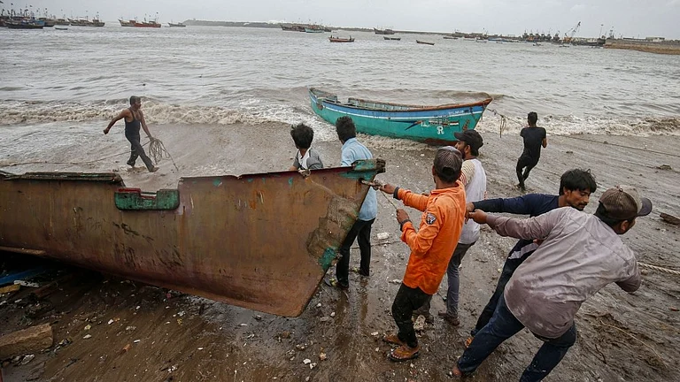
Odisha: Cyclonic Storm Forms Over Bay Of Bengal, May Hit Puri
The low pressure area over the Bay of Bengal on Monday intensified and is likely to turn into a cyclonic storm by October 23 which will cross between Puri in Odisha and Sagar island in West Bengal, the IMD said.
The India Meteorological Department in its latest message said: "…continuing its move the system is very likely to cross north Odisha and West Bengal coasts between Puri and Sagar Island during the night of October 24 and early morning October 25 as a severe cyclonic storm with a wind speed of 100-110 kmph with gusting 120 kmph."
The national weather agency said the low-pressure area over the Bay of Bengal and adjoining Andaman Sea moved west-nortwestwards and lay as a well-marked low-pressure area over eastcentral Bay of Bengal at 1130 hours on Monday.
"It is very likely to move west-northwestwards and intensify into a depression by October 22 morning and into a cyclonic storm by October 23, over eastcentral Bay of Bengal. Thereafter, it is very likely to move northwestwards and reach northwest Bay of Bengal off Odisha-West Bengal coasts by October 24 morning," the IMD said.
The IMD has advised fishermen to return to shore by Monday evening and not to venture into the sea till October 26.
IMD DG Mrutyunjay Mohapatra on Sunday said that Odisha is likely to bear the maximum brunt of the cyclonic storm. The cyclone would spend maximum time on the Odisha coast leading to heavy to very heavy rainfall and high speed wind up to 100 km/hour.
The weather agency has forecast light to moderate rainfall at most places with heavy rainfall at isolated places in Odisha on October 23. Heavy to very heavy rainfall may also occur at a few places with extremely heavy rainfall at isolated places on October 24-25.
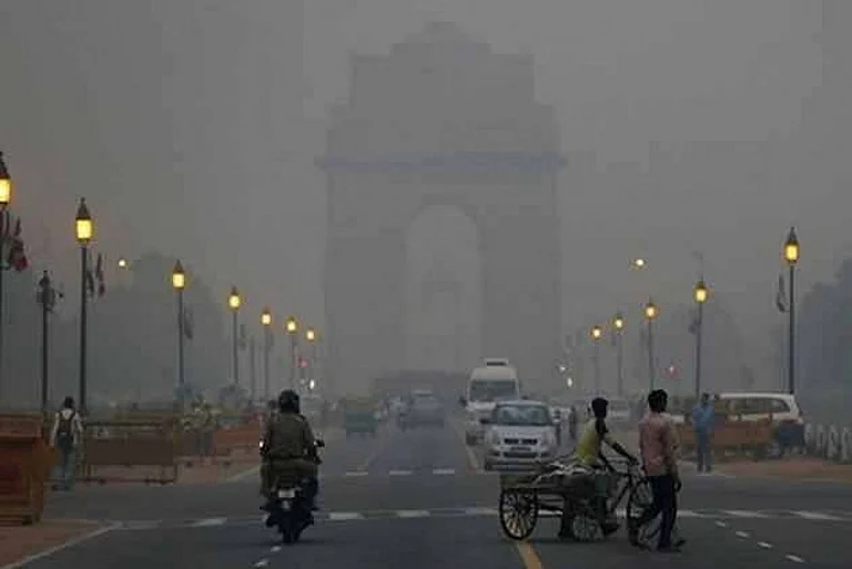
Delhi: AQI Reads 'Very Poor', 26 Monitoring Stations Marked Red Zone
Delhiites breathed in "very poor" quality air on Monday after 94 days, as the city's average air quality index reached 310, prompting the enforcement of GRAP stage II in the national capital.
With the imposition of the second stage of the Graded Response Action Plan in the city, the use of coal and firewood, including in tandoors at hotels, restaurants, and open eateries, as well as diesel generator sets (except for emergency and essential services), is banned.
GRAP is a set of anti-air pollution measures followed in the national capital and its vicinity according to the severity of the situation.
It classifies the air quality in the Delhi-NCR under four different stages: Stage I - 'Poor' (AQI 201-300); Stage II - 'Very Poor' (AQI 301-400); Stage III - 'Severe' (AQI 401-450); and Stage IV - 'Severe Plus' (AQI>450).
Data from the Central Pollution Control Board (CPCB) said the 24-hour average Air Quality Index (AQI) was recorded at 310 at 4 pm on Monday.
Meanwhile, out of 36 monitoring stations in the city, 26 are in the red zone, with AQI recorded in the "very poor" category, according to the data.
As winter approaches, Delhiites are beginning to feel a slight chill in the morning and evening hours, with the maximum temperature on Monday recorded at 34.7 degrees Celsius, two notches above normal, according to the weather department.
The humidity levels fluctuated between 60 per cent and 86 per cent during the day.
The weather department forecast a clear sky on Tuesday and said the maximum and minimum temperatures are expected to settle around 35 degrees Celsius and 20 degrees Celsius respectively.
(With PTI inputs)